Tuesday, August 7, 2018

Mr. President, Mr. President, There's Been An Attack!

Beach, ND to Dickinson, ND
65 miles
1,998 feet ascent
2,264 feet descent
2,942 calories

Surveying The North Forty

Another day in North Dakota and another day of firsts: the first visit to a National Park named after a president, and the first animal attack of the ride---more about that later.

I must confess I had not even heard of Theodore Roosevelt National Park until a few days ago.  But there it was, right on the map.  And that explained the $200 hotel rooms in the tiny town right next to it, Medora.  As I approached it from the west, which was mostly farmland, I wondered what sort of "park" was this going to be?  But as I got closer and meandered through some "mini canyons" it became more like one would expect for a National Park

Scene Outside Medora, ND

Break Time Under The Old Oak Tree In Medora, ND

The Painted Canyon Visitor Center provided one of the more popular viewpoints in the park, showcasing the colors and ruggedness of the landscape.

Painted Canyon, Theodore Roosevelt National Park

Painted Canyon, Roosevelt National Park


After leaving the Park and about halfway to Dickinson, I experienced the first wild animal attack of the ride.  It was the last thing I would have expected, and I was ill prepared.  Not a dog, not a coyote, not a bear, not a cougar.  Not a skunk, not a badger, and not an elk.  It was a hawk!  I heard the cries of a hawk and looked overhead and admired him gliding on the air currents above the field aside the road.  Then he flew over the road , and I remember thinking to myself, "I hope he doesn't drop one on me!"  A few moment later , "WHOOSH", I heard something blow just past my ear from behind, and he flew straight ahead.  Wow, I thought, he must not like me here, and I thought that would be it, but then I saw him go to the right and start circling back for another pass.  This time he was more serious, and I heard a "Whack" on my helmet.  Now he was serious, so I quickly grabbed my camera in the hope I could catch him.  Sure enough, he made one more final pass before leaving me alone.  Never a dull moment!

Attack Hawk On Final Pass

Attack Hawk Readies To Buzz Cyclist


Monday, August 6, 2018

At The Beach--in North Dakota?!

Glendive, MT to Beach, ND
41 miles
1,355 feet ascent
663 feet descent
1,621 calories

Today marked two firsts: the first time in North Dakota and the first time cycling on an Interstate Highway!

Hitting The I-94 On-ramp

There are a few stretches in western North Dakota where the route is actually on Interstate 94.  While it may sound scary, forget those crazy images you may be conjuring up in your head about a non-stop stream of cars whizzing by at 75 mph.  In some areas out here, they just don't have reasonable rural roads for cycling, so Adventure Cycling routes cyclists for some short stretches on the freeway.  The traffic is so light, and the shoulder so broad with a serious rumble strip, that it feels just as safe as some of the country roads.  And, with almost unlimited visibility and no sharp curves, cars can be seen and/or heard long before they are anywhere near, so I can slide all the way over on the edge of the shoulder.  Even then, most drivers are very polite and move over to the passing lane anyway, leaving nearly two full lanes of separation.

It was refreshing to finish Montana and begin working on a new state, "Legendary" North Dakota.  Wibaux, the eastern-most town in Montana, named after a French settler, was the last spot I visited before hitting "the Beach", a town of about one thousand residents.

Quirky Lawn Art In Wibaux, MT

So Long, Montana


Hello, North Dakota

Ranching and farming are the two main areas of commerce in the Beach area, and I saw two trains go by today.  So, even though it is remote, it is easily accessible with it's close proximity to the Interstate and BNSF railroad.  Teddy Roosevelt is from an area not too far from Beach, and Roosevelt National Park is just east of Beach.

Downtown Beach Lunch Stop

Sunday, August 5, 2018

Down To The Yellowstone River and "Montana Speak"

Circle, MT to Glendive, MT
51 miles
869 feet ascent
1,134 feet descent
2,239 calories

Eastern Montana is the home of Makoshika State Park, the largest in the state.  "Makoshika" is a Sioux word, which loosely translated means "the bad lands".  It is not too far from the more famous Bad Lands in South Dakota.

Eastern Montana Near Glendive

"Stolen Land" House Between Circle, MT & Glendive, MT
(Not sure why that was written on the house, but surely there is a story behind it)

Glendive is a town of roughly five thousand residents and sits along the Yellowstone River as it flows northward to the Missouri River.

The Muddy Yellowstone River, Glendive, MT

During Lewis and Clark's return journey from their winter on the Pacific coast, they split the Corps of Discovery into two crews in western Montana.  One group retraced their outbound journey on the Missouri River, but the other explored the Yellowstone River and followed it until it joined with the Missouri, where they rejoined the rest of the Corps.

The scenery did not change much again today, but a very cool thing happened as I rolled out of Circle.  Coming around a bend in the road I saw a fox on the side of the road chowing down on something.  He was so involved he never heard or saw me until I was about twenty feet away.  As soon as I reached for my phone though, he heard me and took off like a rocket!  Foxes are fast; really fast.  He must have covered a hundred yards in ten or fifteen seconds and I never saw him slow down.

As I near the end of Montana, here are a few things I've learned and will share if you ever venture this way:

In Montana it's not "you're welcome", it's "you betcha!"

If you aren't driving a truck, preferably a diesel one, then you probably aren't from Montana.

If you have to ask the waitress what "gems" are, you definitely are not from Montana.

"Gumbo" is not something you eat in Montana; here it means mud.
(Sorry, Connor)

Saturday, August 4, 2018

Circle The Wagons

Jordan, MT to Circle, MT
68 miles
2,493 feet ascent
2,651 feet descent
3,214 calories

Eastern Montana is, relatively speaking, fairly flat with a general elevation of 2,500 to 3,000 feet.  However, it is deceiving because it is very hilly and looking at a map one would never know.  A "roller coaster" road would best describe the route between Jordan and Circle.  The "nothingness" continued for miles outside of Jordan, but then gave way to some interesting, rocky, eroded hills.

Eastern Montana Near Fort Peck

Soon after riding through the dusty hills, I looked down at my odometer and saw it was going to hit the 1,000 mile mark.  So, I took a shot of the milestone when the odometer rolled back to zero and started counting again-still a long way to go though!

1,000 Miles

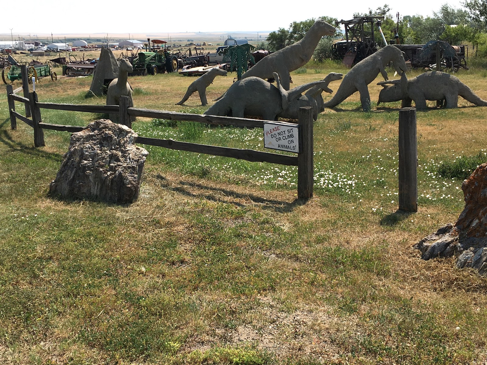
In Jordan, MT they have a museum with dinosaurs and other historical items, but it was closed, so all I could take in were the replicas outside and some old tractors.
Dinosaur Field In Circle, MT
Old Tractors In Circle, MT

After not seeing any cyclists for about a week , I finally ran into another one today at the motel.  Roger from New Zealand and his friend are riding the Northern Tier route from Boston to Seattle.  Speaking of the motel, the Travellers Inn is the only game in town, so if you want to stay in Circle, you can stay at the Travellers Inn or the Travellers Inn.  Well, there was one other place, but I couldn't find the manager.

"Free" Motel

The man who runs the Travellers Inn is eighty-four years old, spry as can be,  and is also the local John Deere dealer, so I figured I would give him a plug.

Serious Tractor By John Deere

Friday, August 3, 2018

And Then There Was Nothing....

Mosby, MT to Jordan, MT
52 miles
1,870 feet ascent
2,029 feet descent
2,176 calories

Leaving such a cool place as the Hill Ranch Oasis is tough, but the road beckoned, and it's high time to get out of this state. 

Dolores With The Hill Ranch Oasis B&B's New Sign

Nothing against Montana, but by my count I have been here eleven days!  The state just goes on and on, and today it became the most desolate I've seen it yet; no farming and very little livestock.  Virtually nothing.  There were more abandoned sites than anything else.

Eastern Montana


Old Abandoned Site

Break Time At Dry Creek

The most entertaining part was looking at some of the odd names chosen for the ranches.  Did they think these through?

The Lo Bar Ranch

Hooker Livestock


Jordan is another small town with a population of just a few hundred and only two or three places to eat.  I chose the "R- Ranchers Bar" for a cheeseburger and fries, and I got a few odd stares from the locals, but I am used to it by now.

Local Checking Me Out At The R- Ranchers Bar


Downtown Jordan, MT

Thursday, August 2, 2018

To The Oasis

Winnett, MT to Mosby, MT
27 miles
988 feet ascent
1,116 feet descent
1,285 calories


Eastern MT

Weather indicated that today should be a short ride/rest day as the mercury was forecast to hit 100 degrees.  In Montana? Oh well.

It was probably the easiest 27 miles so far though as a strong tailwind made for easy going, even up the few hills that were on the route.  The  scenery is not much different than yesterday, but at the Hill Ranch Oasis B&B where I'm staying they have a rare stuffed jackelope!

Jackelope!

The Hill Ranch Oasis is popular with hunters who come for the wide variety of game in the area.  It is also popular with cyclists and others.  Tonight there are two hunters, two oil workers, and one cyclist, but the hosts seem to take it all in stride as they have been doing this for twenty years.

Hill Ranch is still a working ranch with, sheep, cattle, and a few horses right outside the house.  It is quite a place.

Lamb Trying To Break Out

That's A Bull!

Old Original House On Ranch


Wednesday, August 1, 2018

In It To Winnett

Lewiston, MT to Winnett, MT
53 miles
918 feet ascent
1,781 feet descent
2,005 calories

Eastern View From The Judith Mountains

Judging from the more than eight hundred foot drop in elevation, today should have been an easy ride, and it would have been if not for the winds.  The man from the hotel told me on the phone yesterday to hope for tailwinds.  I did, but hoping doesn't always make it so.

After crossing over the Judith Mountains, which were lush with greenery, the landscape again turned arid, and by the time I reached Winnett, it looked like West Texas once more.

Winnett Landscape 

Winnett is tough little town, hanging on to what remains.  One grocery/general store and one bar/restaurant/hangout are the only signs of commerce beyond livestock and some farming, which seemed more focused on hay than on any crops.

Winnett Courthouse

Thank goodness it is here though, along with the Northern Motel.  For without them, cyclists like me would really have it rougher.

The Northern Motel 

Final Tallies from GPS