Tuesday, July 31, 2018

Where Eagles Soar

Denton, MT to Lewistown, MT
42 miles
1,801 feet ascent
1,414 feet descent
1,890 calories

It is not every day that you see a bald eagle in the wild, and until today I had only seen it once before.  But during a break today at the "Gigantic Warm Spring" one circled overhead for a few minutes before gliding into the hills.  Pretty cool.

Gigantic Warm Spring Turnoff

It was a mile off route down a dirt road, but curiosity got the better of me, so I said "what the heck, it's only a mile" and went exploring.   The lady at the house said the spring runs year round at 68 degrees and pumps out thousands of gallons per minute.

Gigantic Warm Spring

Bald Eagle

There's the eagle riding the currents.  I wish I had my good camera and long lens to get a better shot, but I have to admit my little iPhone camera does a pretty good job.

The road from Denton to Lewistown wound through more of the "golden triangle" of farming, as I've learned it's called by the locals.  The farms are very large now, so the landscaped is littered with old abandoned houses, but you still see other homesteads.

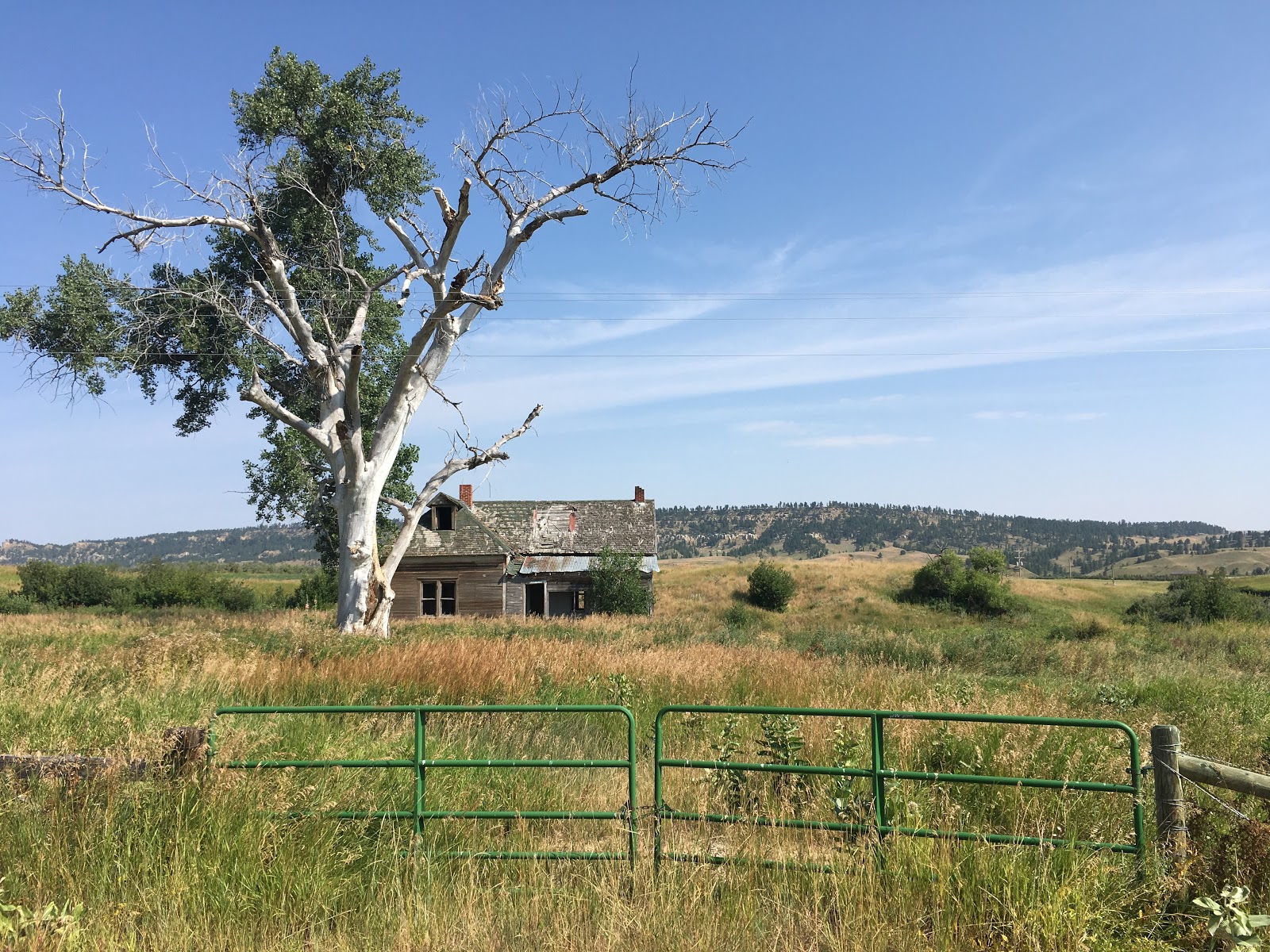
Old, Abandoned House
Little House on the Prairie


The last interesting site I came across today, two of them actually, was this:

Mystery Site

Do you know what is is (click on the picture for a larger view).


Benton to Denton (I thought that was in Texas)

(Yesterday, July 30)
61 miles
2,185 feet ascent
1,181 feet descent
2,441 calories

Climbing out of the Missouri River valley in Benton was only the beginning of a gruelling day, as the temperature rose into the nineties and the hills never seemed to end.

Scenic Abandoned Ranch

The scenery kept things interesting though, and eventually I made Denton in seven hours, the longest day yet.  It certainly was full of events though. 

That "Apple Maps" van passed me again for the second time in two days, this time just as I was riding into Geraldine, MT.  I'm beginning to wonder if that's just a cover, and if Apple is developing  automotive technology like all the rumors say?

The route passed by Square Butte, named appropriately enough, but which I later found out has another more significant characteristic due to it's geological nature.  Apparently, it is only one of two places in the world where a certain type of volcanic rock can be seen.  I learned this while taking a break at a scenic view point.

Square Butte

I also encountered another interesting piece of nature while taking the photo below at the break.

Break Time

While looking out over the vast wheat field, I heard what sounded like another loud bug, but then I realized it was not a bug but a rattlesnake letting it's presence be known!  Fortunately, he was off the concrete pedestal, so I let my presence be gone.  Yes, Virginia, they do have rattlesnakes in Montana.

While chatting with Lester and Dick, two locals, at the Longbranch Bar/Restaurant/Casino/local hangout (the only thing in town open after 6:00), they told me the area only gets about 13 inches of rain per year.  That explained why I saw cactus, and why some parts of the ride reminded me of west Texas.

The Longbranch (Denton, MT)


Dry Lake bed (Stinky Lake I call it)
Square Butte
The Debt Inn

Sunday, July 29, 2018

Soldiering On To Fort Benton

Great Falls, MT to Fort Benton, MT
53 miles
1,653 feet ascent
1,657 feet descent
1,788 calories

Into The Great Wide Open

Two days of rest was just what the doctor ordered and alleviated most of the back pain, so I "soldiered on" today to Fort Benton, MT.  There were no trees in sight for most of the ride until reaching the Missouri River again in Fort Benton.  In hindsight, it might have been just as easy to grab a raft in Great Falls, throw my bike onboard, and just float down the river.

Just a few miles after turning north onto Highwood Road from Hwy 87 east of Great Falls, a non-descript, white van looking like an autonomous vehicle came towards me from the opposite direction.  As it passed, I saw "Apple Maps" written on the side of the van, so maybe I will be one of those people with obscured faces on Apple Maps in the near future!

There wasn't much between Great Falls and Fort Benton but farmland.
Still, it is very scenic.

Farmland East of Great Falls

Also, I came across the first west bound riders I've seen in a week or so.  Ericka and Ken were from Brooklyn, left from there June 1st, and are headed to Seattle as their final destination.

West Bound Riders Ericka & Ken

Tonight I am staying in the Pioneer Lodge Hotel.  Originally built in 1916 as a two story mercantile, it closed years later.  In 1986 it was remodeled into a hotel by Marvin and Sunny Appleby, and is run today by their daughter Susie.

Pioneer Lodge Hotel

In it's heyday Fort Benton was a large commercial junction between riverboats that came up the Missouri and traders and trappers that came from the west.  With the advent of rail travel though, fewer riverboats came, and today Fort Benton is a sleepy river town of about one thousand residents.

Missouri River, Fort Benton, MT

George Montgomery Statue in Fort Benton


While it seems like a very low stress environment, apparently some of the locals prefer to go shoot their guns in a more stressful surrounding!


"Extreme Stress Shooting" Gun Range


Saturday, July 28, 2018

Backing Down in Great Falls

Unfortunately, one day of back rest doesn't seem to be doing the job.  I am going to rest again today, Saturday, in Great Falls in the hope that one more day might do the trick.  If that doesn't work, I plan to rent another car and drive a day or two and see if it will be good enough to resume riding again.

During the downtime yesterday I took the opportunity to visit the Lewis and Clark Interpretive Center and the Great Falls on the Missouri River.  Much of the Missouri is now controlled by dams, but the dams were built upstream of the falls in order to preserve the falls.

Lewis & Clark Interpretive Center

Rainbow Falls

The Great Falls are actually a series of  five falls stretched over a few miles.  Because it is late Summer, the flow is somewhat low, and some of the falls are not so "great."  Still, it is easy to imagine them in Spring when the snow melt driven flow is at full throttle.  The dam at Rainbow Falls generates 60 megawatts of power, enough to supply the needs of around 45,000 homes.  Pretty impressive.

Ryan Falls

Ryan Falls Panorama

Two things I did not expect to see in Montana were pelicans and seagulls.  And, yet, there they were.

Pelican on the Missouri River

Maybe they were blown into town by a storm or weather front, but I can't imagine them surviving a winter here.

The drive to Ryan Falls went through an infinite expanse of wheat fields, some already harvested and some almost ready, but it was quite a sight.  It is staggering to think how much wheat they produce.

Out Standing in my Field : )

Perhaps I should have tried a three-wheeled, recumbent bike like this veteran uses......


Thursday, July 26, 2018

Butts & Prairie Dogs, Butts & Prairie Dogs!

Augusta, MT to Great Falls, MT
54 miles
522 feet ascent
1,184 feet descent
1,883 calories

Mountain View from Augusta, MT

The mountains slowly faded from view on the road from Augusta, MT to Great Falls, MT and were replaced with butts and prairie dogs. Everywhere.  All along the road prairie dogs stood up and checked me out, then squeaked their high pitch cries to warn their buddies ahead of my approach. Unfortunately, I could never get close enough to one for a good photo.  Further away from the road the landscape was filled with butts: rocky butts, smooth butts, high butts, and low butts.

Scenic Butts

Oh, wait a minute, stupid spellchecker, that's "buttes", not "butts"!

Actually, there was wildlife everywhere as I saw deer, around thirty, a fox, prairie dogs, of course, and even some llamas.

Thanks to the locals' knowledge in Augusta, the road closure did not affect bicycles, and I was able to easily portage around the broken bridge.  I probably could have ridden on it for a thrill.

MT Rte. 21 Road Closure
MT Rte. 21 Bridge Collapse

Although the route was supposed to be all downhill today, there were some minor hills to contend with, but more troublesome was the wind.  Although it constantly changed direction,  for the most part it was a headwind.  By the time I neared Great Falls, the weather threatened and some raindrops fell, but nothing of any consequence where I was.  However, a severe thunderstorm warning was issued just after I arrived.

Threatening Storm

While walking down the street for dinner, I noticed it was all barricaded off for some reason.  I asked the folks in the restaurant what was going on, and they said it was the annual Pet & Doll Parade, which occurs the night before the fair opens.  Naturally, I had to check it out.

Losin' His Britches in the Pet Parade

Little Buckaroo

Parade Watcher (yes, dogs can drive in Montana)

Near the end of today's ride I finally reached the Missouri River in Great Falls.

Missouri River in Great Falls, MT

Lewis & Clark followed the Mjssouri all the way up here, and beyond, from St. Louis.  Their great portage took place here, so I'm going to take some time off and visit the Lewis & Clark Interpretive Center, check out the falls, and try to nurse my back to health.  It has not improved from yesterday, and riding today was probably not a good idea.


Wednesday, July 25, 2018

Across the Great Divide

Lincoln, MT to Augusta, MT
56 miles
2,497 feet ascent
2,864 feet descent
2,373 calories

The Continental Divide

It wasn't until yesterday when I was looking at the map that I realized I would be crossing the Continental Divide today.  I was more interested in how many climbs and how high they were.  Then I saw the dotted line on the map and said "oh, crap, this could be trouble!"  Fortunately, it was "only" at 5,600 feet elevation where I crossed, instead of something insane like ten thousand feet.  Still, it was not a pretty sight.  After waking up with a tweaked back from a squishy hotel bed, I headed out of Lincoln in a cool 55 degree morning.

Heading up to Rogers Pass
Threatening Weather Before The Pass

Then, headwinds and uphill climbing meant three hours to cover a measly 17 miles.  But at the pass, things began to come together, and the eastern slope meant an eight mile glide downhill and warmer temperatures.  However, before that I had to spit on the Divide so my DNA would make its way to both oceans! (Other people do something else, but this is a PG-13 blog.)

Grizzly Rider

The change in landscape was quite dramatic as trees nearly disappeared within just a few miles.

Eastern Slope of Continental Divide

The Road Down Rogers Pass

Things are quite desolate once out of the mountains, but the wide openness makes it clear why they call Montana "Big Sky Country".

East of Rogers Pass

Jill, Raymond, Brenda, Donna, Mr. & Mrs. Davee (just wanted to say that)  thank you for the nice card you sent to my parents place.   My Mom read them to me on the phone today.  That was very thoughtful of you!

I made it to Augusta today on a gamble.  At the turnoff to Augusta, there was a big Montana Hwy Dept sign that said the road I plan to take out of Augusta tomorrow is closed.  Uh-oh.  The options were going all the way to Great Falls, another 48 miles (not likely) or sticking with Plan A, 20 more miles to Augusta and seeing if I could get through the road closure on bike or relying on locals.  Fortunately, when I checked in to the Bunkhouse Inn, the receptionist said you can walk or bike across the bridge that washed out.  Dodged another bullet.  The Bunkhouse Inn is a cool, old Bunkhouse from the early 1900's with simple rooms and shared bathrooms.

The Bunkhouse Inn

Trying to get all those calories in 


Tuesday, July 24, 2018

The High Plains of Montana

Lubrecht Experimental Forest (Greenough, MT) to Lincoln, MT
49 miles
1549 feet ascent
1095 feet descent
1861 calories

Montana High Plains Panorama
(Click for full view)

For the first time since leaving Seaside, OR, it was shivering cold this morning.  The cabin in Lubrecht was at around four thousand feet elevation, and it took two wool blankets to stay warm at night.  But it was good sleeping weather.

The route from Lubrecht to Lincoln  started near the Paws Up Ranch, crossed the Blackfoot River, and then paralleled it nearly all the way to its headwaters.

Break Time on the Blackfoot River

The disappointment Lewis & Clark felt upon seeing the many mountains in Montana instead of an open ocean would have been offset by the magnificent views.

Mountain View from Ovando, MT
Downtown Ovando, MT

The mountains are beginning to spread out a bit more, and clouds were visible for the first time since Oregon.  Meadows are everywhere, which makes for good ranching, with horses and beef cattle everywhere.

High Altitude Meadows
Who Are You?


This is also close to areas where dinasours lived at one time.  I even ran into Dino the dinasour.  Remember him?

Beef Cattle & Dinasours

If you think I am crazy, these two guys I ran into checking into my motel (Three Bears Motel) are riding the Great Divide, going border to border, from Canada to Mexico along the Continental Divide on mountain bikes.  No thanks.

Great Divide Riders

Final Tallies from GPS