50 miles
259 feet ascent
371 feet descent
1,779 calories
It's rare when you can ride fifty miles and only experience a few hundred feet of change in elevation, but most of today's route was again on converted railroad paths, so there was minimal change in grade.
Lake Wobegon Trail
This time it was a continuation of the Lake Wobegon Trail and then the old Soo Line extension into Little Falls, where Charles Lindbergh spent much of his childhood. A lot of the Soo Line was through dense, wooded areas, making the ride feel like a trip through a forest.
Soo Line Extension
It even included a covered bridge, the first I can recall for a bike path.
Lake Wobegon Trail Covered Bridge
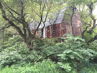
There are also lots of other cool sights along these retired railroad paths like this old abandoned barn.
Rusted, Metal-sided Barn
Geese Outside Freeport, MN
Wild Turkeys
Dam South of Little Falls, MN
According go my GPS, I was crossing Zebulon Pike Lake. OK, I thought, but then when I got to the other side of the bridge, there was a sign that read "You Just Crossed The Mississippi River. What? Sure enough, that was it! This far north, however, the Mississippi is fairly small and narrow, so one can be easily tricked. I thought I would not cross it until the Minnesota-Wisconsin border. Shame on me for not knowing my geography better; that will be the St. Croix River.
Legends abound up here, so I keep my eyes and ears open for a possible sighting, like the one below.
"Sasquatch"?


No comments:
Post a Comment